


Harding County Precinct 2, Harding County, New Mexico
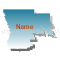
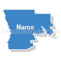
About
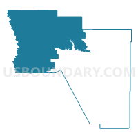
Outline

Summary
| Unique Area Identifier | 623608 |
| Name | Harding County Precinct 2 |
| County | Harding County |
| State | New Mexico |
| Area (square miles) | 799.86 |
| Land Area (square miles) | 799.72 |
| Water Area (square miles) | 0.15 |
| % of Land Area | 99.98 |
| % of Water Area | 0.02 |
| Latitude of the Internal Point | 36.01608310 |
| Longtitude of the Internal Point | -104.10466580 |
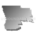
Maps


Graphs
Select a template below for downloading or customizing gragh for Harding County Precinct 2, Harding County, New Mexico


Neighbors
Neighoring Voting District (by Name) Neighboring Voting District on the Map
- Colfax County Precinct 5, Colfax County, NM
- Harding County Precinct 1, Harding County, NM
- Mora County Precinct 11, Mora County, NM
- San Miguel County Precinct 14, San Miguel County, NM
- San Miguel County Precinct 15, San Miguel County, NM
- Union County Precinct 4, Union County, NM
Top 10 Neighboring County Subdivision (by Population) Neighboring County Subdivision on the Map
- Clayton South CCD, Union County, NM (3,730)
- Springer CCD, Colfax County, NM (2,213)
- Wagon Mound CCD, Mora County, NM (1,004)
- North Harding CCD, Harding County, NM (564)
- Conchas Dam CCD, San Miguel County, NM (278)
- Trementina CCD, San Miguel County, NM (184)
Top 10 Neighboring Place (by Population) Neighboring Place on the Map
Top 10 Neighboring Unified School District (by Population) Neighboring Unified School District on the Map
- Las Vegas City Public Schools, NM (13,348)
- Clayton Public Schools, NM (3,976)
- Springer Municipal Schools, NM (1,820)
- Wagon Mound Public Schools, NM (644)
- Roy Municipal Schools, NM (393)
- Mosquero Municipal Schools, NM (253)
Top 10 Neighboring State Legislative District Lower Chamber (by Population) Neighboring State Legislative District Lower Chamber on the Map
Top 10 Neighboring State Legislative District Upper Chamber (by Population) Neighboring State Legislative District Upper Chamber on the Map
Top 10 Neighboring 111th Congressional District (by Population) Neighboring 111th Congressional District on the Map
Top 10 Neighboring Census Tract (by Population) Neighboring Census Tract on the Map
- Census Tract 9507, Colfax County, NM (5,688)
- Census Tract 9552, Mora County, NM (4,881)
- Census Tract 9502, Union County, NM (4,549)
- Census Tract 9575, San Miguel County, NM (4,395)
- Census Tract 1, Harding County, NM (695)
Top 10 Neighboring 5-Digit ZIP Code Tabulation Area (by Population) Neighboring 5-Digit ZIP Code Tabulation Area on the Map
- 87701, NM (20,081)
- 87747, NM (1,624)
- 87752, NM (431)
- 87743, NM (361)
- 87733, NM (158)
- 88424, NM (128)
- 87746, NM (120)
- 88422, NM (68)
- 87730, NM (27)